Portion of the Paleozoic relevant to the bedrock of Niagara from the International Chronostratigraphic Chart
1 media/Escarpment Periods ICS_thumb.JPG 2021-05-20T17:10:05+00:00 Justin Pentesco e1b177acadc784b8497de179c36bc8e98f92c5e3 22 2 A portion of the chronostratigraphic chart. The whole chart can be found here: https://stratigraphy.org/chart plain 2021-05-20T18:41:42+00:00 www.stratigraphy.org Justin Pentesco e1b177acadc784b8497de179c36bc8e98f92c5e3This page is referenced by:
-
1
media/IMG_8721b.jpg
media/20210615_132624cr.jpg
2021-05-17T16:04:26+00:00
The Niagara Escarpment, 450 million years into the past
61
image_header
2023-11-14T19:35:47+00:00
The Niagara Escarpment provides a playground for residents of Niagara, a refuge for wildlife, a preserve of natural biodiversity, an invaluable area of groundwater recharge and emergence, and of course is a window into the geological past. Brock University is situated right at the top and the protected escarpment is literally right out the University's back door. We will explore the Niagara escarpment here in a geological context by examining its form, the materials of which it is made, and the processes that lead to its existence and morphology.
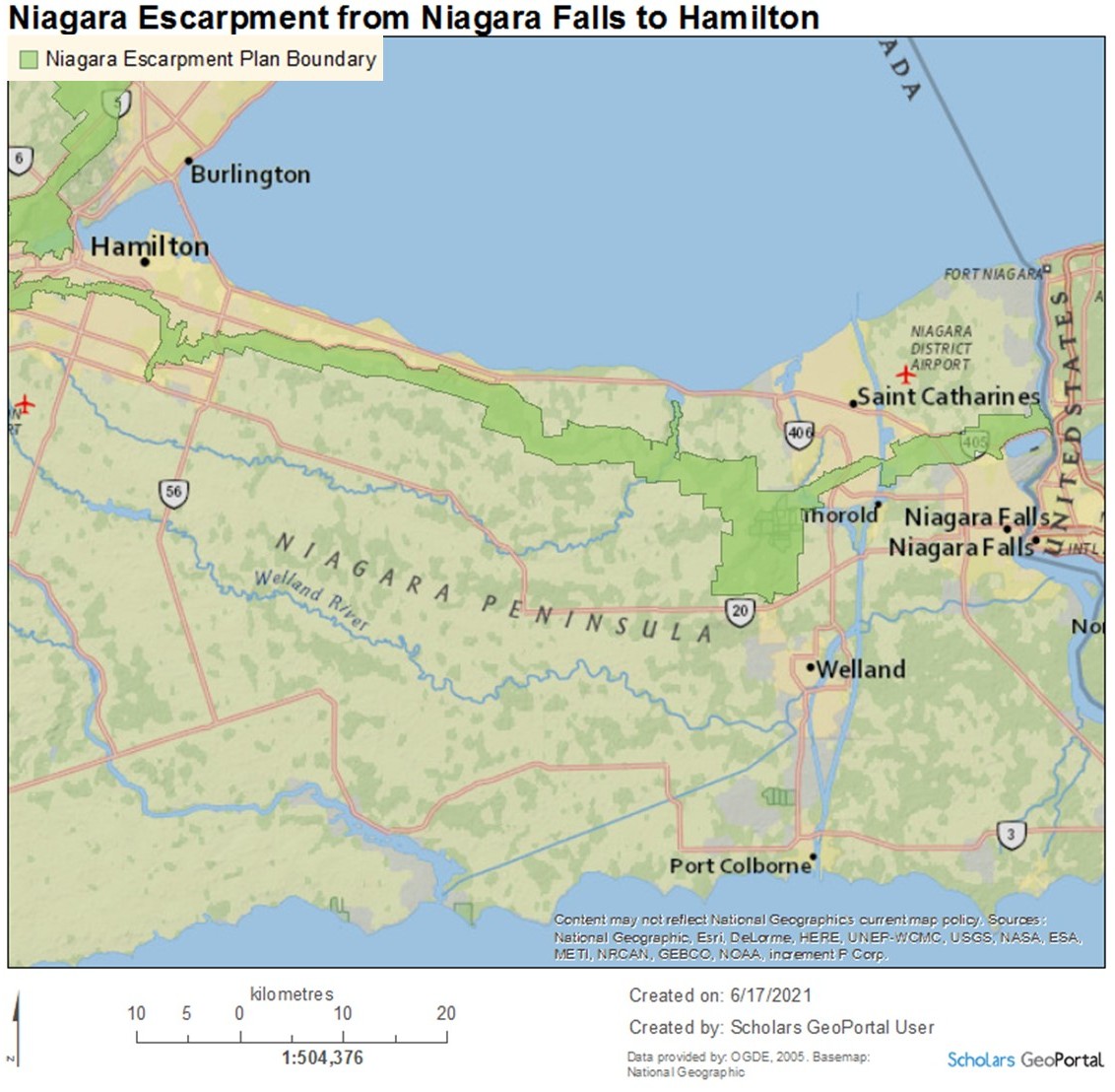
The Escarpment (we drop Niagara locally) is a topographic feature called a cuesta commonly described as a scarp, a cliff, or a ridge, which is visible in Ontario from Niagara to Manitoulin Island. The Escarpment’s relief varies from tens to hundreds of feet and its form today is a product of erosion, much of which was the result of ice sheets which once covered southern Ontario. It is composed of several layers of shale, sandstone, and dolostone.
The Escarpment actually extends further than Ontario (rocks don't care about our silly human boundaries) from east of Rochester, NY, across Manitoulin Island, and further through Lake Michigan’s western coast into Wisconsin. Because of the extent of the Escarpment, the rock units composing it change somewhat from one end to the other, largely a result of what was deposited in that place hundreds of millions of years ago and what was eroded before it could be covered with more sediment.
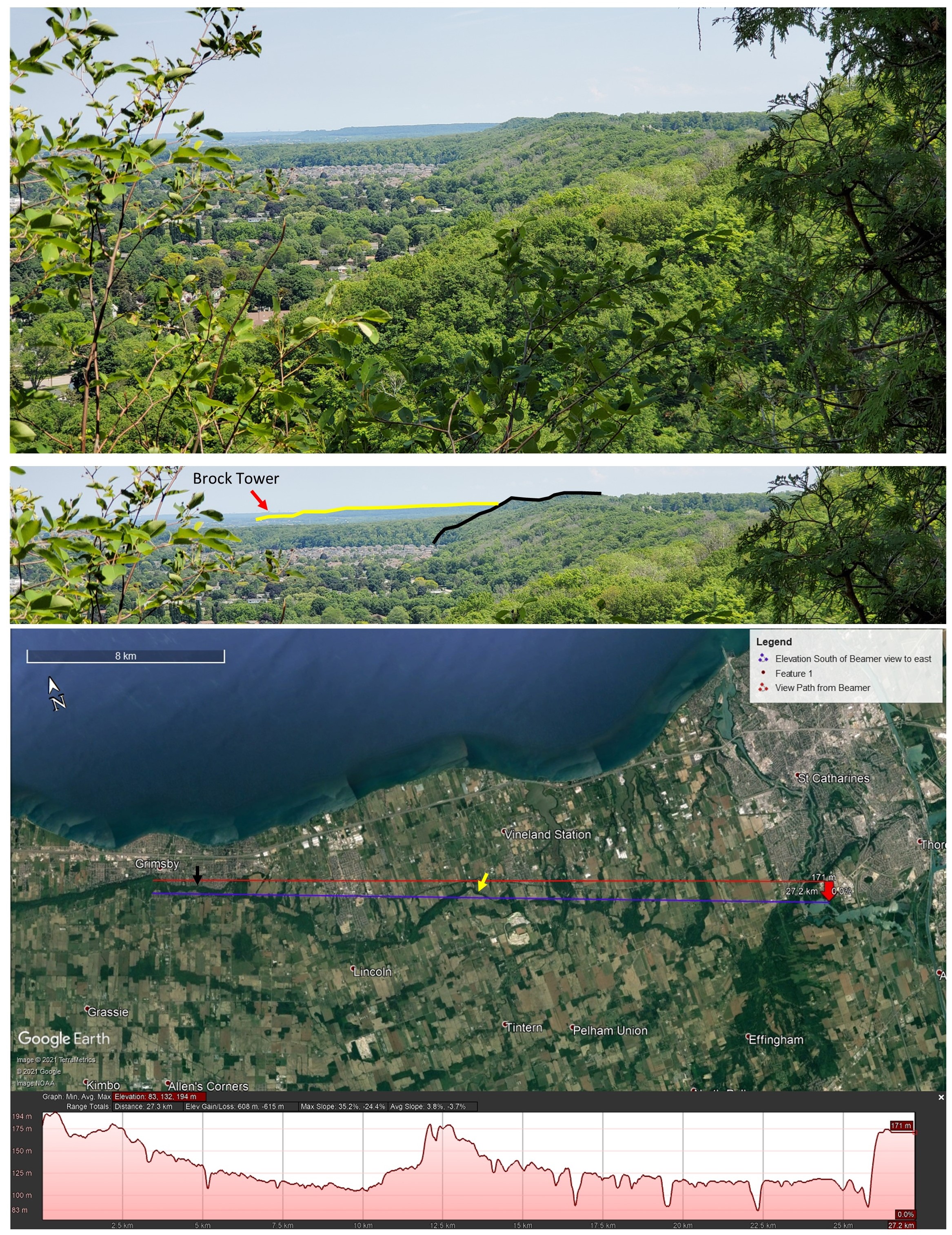
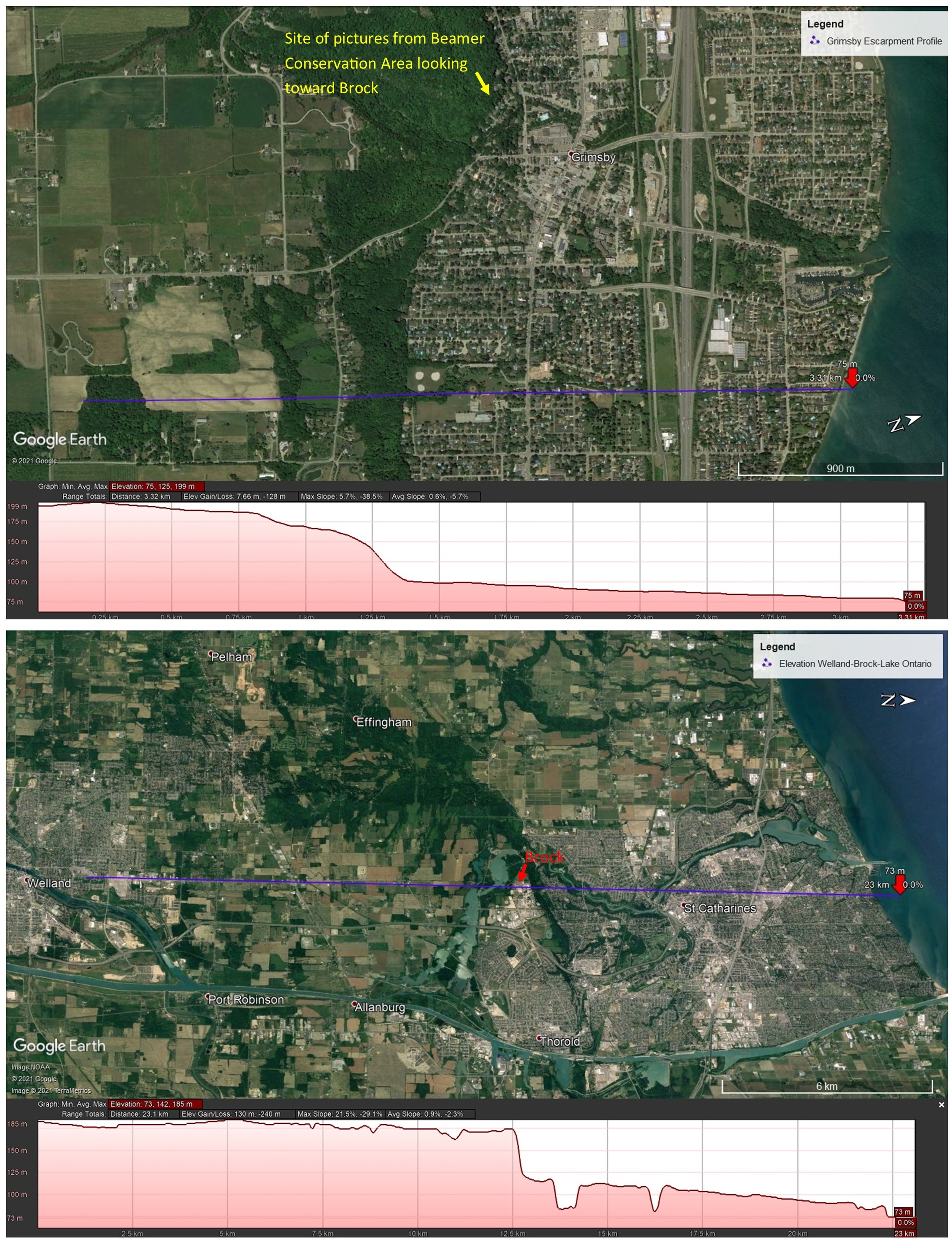
To get a sense of the relief of the Niagara Escarpment around Brock, take a look at the pictures below that show the view to the east from about 180 meters elevation (above sea level, or asl) right above Grimsby at Beamer Memorial Conservation Area. Since we are looking eastward, we are looking along the Escarpment, the middle image outlines the visible Escarpment relief, the satellite image below illustrates the viewpoint from above and shows the topographic relief between the viewpoint and Brock. In the satellite image you can trace the outline of the Escarpment as the dark green lineation running roughly west-east. Way off in the distance from our viewpoint, Brock's prominent Schmon Tower can just barely be seen (the red line starts where the picture was taken in the west and ends at Brock's tower), with a face of the escarpment protruding between the vantage point and Brock's position (outlined in yellow). This can be seen on the elevation profile at the bottom, which follows the purple line on the satellite image of northern Niagara.
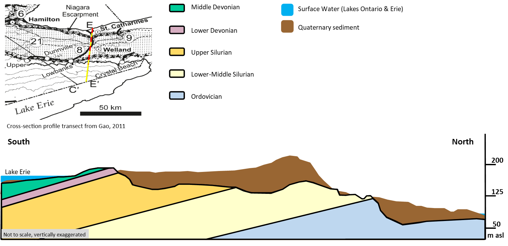
The profile of the Escarpment is characteristically steep facing north (in Niagara) as you can see in the elevation profiles below, the first from the western end of the peninsula, and the second forming a northward line from Welland, through Brock's Campus, and on to Lake Ontario. (you can always view the full size image by clicking on it and selecting View Source File)
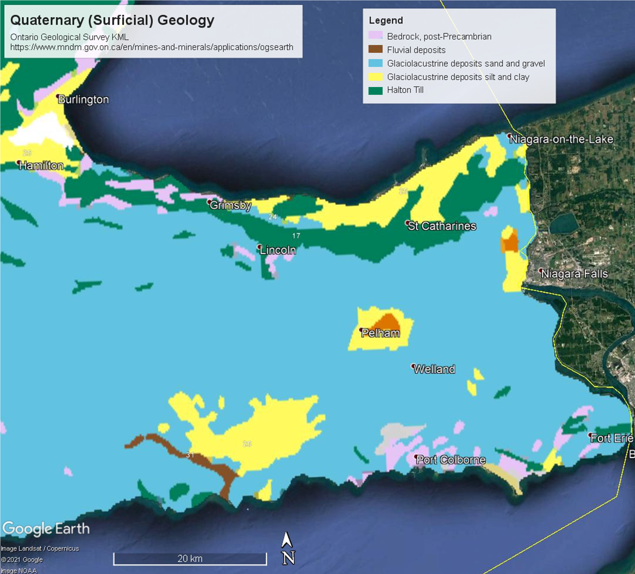
Today most of the Niagara Region is covered in sediment from glacial lakes that preceded the Great Lakes as we know them today (see the map below). This is an amazing story in itself, but it all happened in the most recent geological past, in the Quaternary Period (and even then in just the last bit of the Quaternary) and right now we are interested in what is below the surface and as such what was on the surface in the past. The Escarpment lets us see the bedrock without even having to put a shovel in the ground. We will return to the recent geological history later to discuss the glaciation and erosion of the Escarpment.
All of the rock units visible on the Escarpment's face continue underground to the south. These units have been eroded and largely removed to the north of the Escarpment. Under the Quaternary deposits of eroded rock, soil, glacial deposits, and lake deposits are bedrock units of great age. On a large scale, the bedrock geology of Niagara is very simple, about as structurally simple as geology can be. There are several layers originally laid down horizontally, stacked on top of each other and sitting at a slight angle (we call that dip) such that the layers angle down to the south. These layers reveal the history of the region hundreds of millions of years in the past.
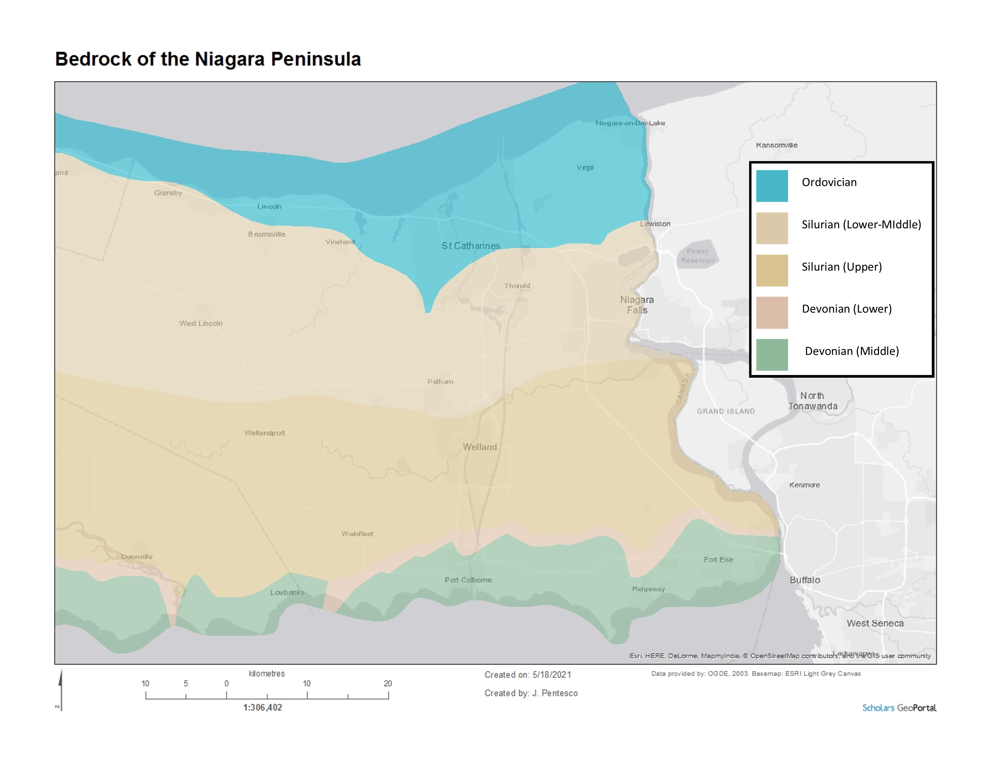
Below is a map with the rock units identified by their age. The Escarpment generally outcrops along the north side of the Silurian bedrock (where the tan colour meets blue) but the bottom-most layer of those Silurian rocks may extend north ahead of the Escarpment. This is all dependant on how the Escarpment rock was weathered in each locality. Remember that in Niagara the bedrock at the surface gets younger as you go southward.
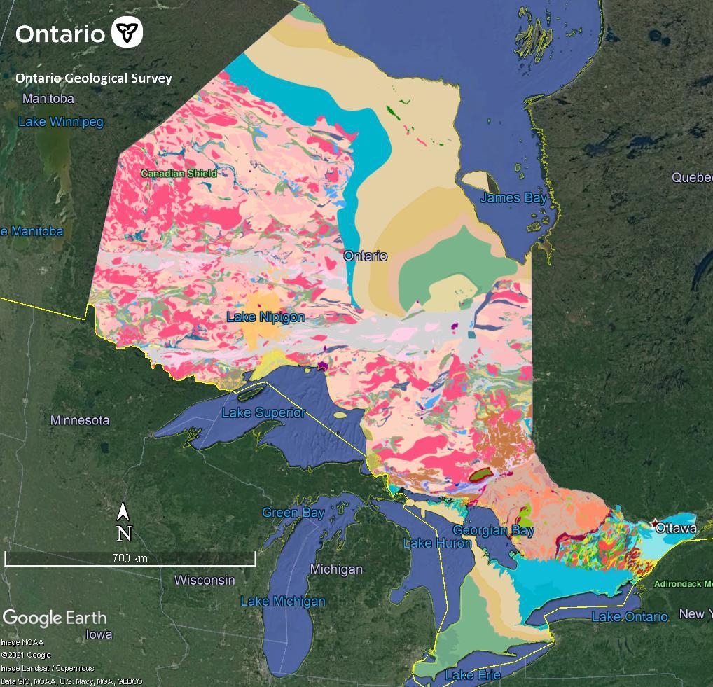
To compare, if you're interested, below is what the bedrock geology of Ontario looks like at a large (1:250k) scale (click on it to enlarge). You may notice that the "middle" of Ontario is quite complex but both the north and south have simpler arrangements of similar aged rock. That middle bit, at least north of Lake Huron, is some of the oldest rock on the planet, the Canadian Shield. It was there long before the sediments of Southern and Northern Ontario were deposited on its flanks. In the south, between the Shield and our much younger Paleozoic (541 to 252 Ma, meaning between 252 million years ago and 541 million years ago) sediment are the Central Metasedimentary Belt and the Central Gneiss Belt, but that's a different story... The take-away from the map below regarding the Escarpment is that the sediments were deposited on the flank of older rock. Niagara's bedrock has a story that largely occurs in the Ordovician, Silurian and Devonian Periods, which is what we will discuss in the next couple sections.
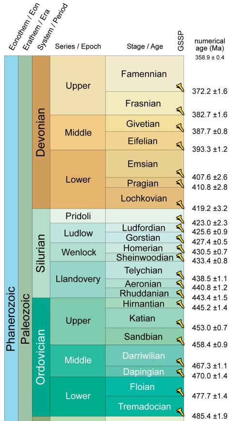
The Ordovician, Silurian, and Devonian are Periods, as set out by the International Commission on Stratigraphy which is the authority on such matters. A Period is a subdivision of geologic time, with larger units being Eras and then Eons. Below is a portion of the chronostratigraphic chart relevant to Niagara's bedrock which includes the time in millions of years (Ma for mega annum). As you can see, the bedrock of Niagara including the Escarpment predates the dinosaurs (which lived in the Mesozoic, 252-66 Ma) but is much younger than most of Ontario which is Pre-Cambrian (>541 Ma). You can get the full chronostratigraphic chart here.
To develop an understanding of the Escarpment without trying to become experts (for now) we will focus on the composition of the Escarpment in the neighbourhood of Brock University south of Lake Ontario. In particular we will follow the units as they have been revealed by erosion at Niagara Falls. The rock of the Escarpment largely falls into three categories: shale, sandstone, and limestone/dolostone. So the next section will explain what those are and in what types of environments they form. Feel free to skip around if you like by using the index at the bottom of this page.
Interested in chemistry, biology, and physics, but looking for a way to combine them all?
Through Earth Sciences you can become a Geologist or Environmental Geoscientist who applies those subjects to our natural world. One of the great things about the geological and environmental fields is that they allow you to combine your knowledge of seemingly disparate scientific disciplines to further our (humans that is) understanding of our own planet and our neighbouring planets. Some people in geology/environmental science work in labs, some in the field, and many in a combination of both.
You can learn more about options to study here: Brock Department of Earth Sciences. -
1
media/background_Strat Column40.jpg
media/IMG_8741.JPG
2021-05-17T16:37:10+00:00
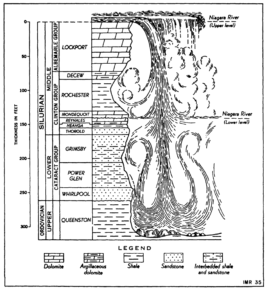
The Escarpment in layers
12
A quick look at the stratigraphic components of the escarpment
plain
2021-05-25T14:04:35+00:00
Even in the Niagara Region there are local variations in which units are present in the escarpment (the Neahga Formation appears in some areas of Niagara and not in others, ditto for the Thorold Formation). Since the rocks of the escarpment are sedimentary, not all were deposited in all places (originally, as sediment), and some of the material that was deposited was eroded away before it could be turned to rock (lithification) leaving a gap in the rock record called an unconformity.
We are about to get into some ages, so a note here that ages recorded in Ma refer to mega-annum meaning million-years, and m.y. refers to an interval of time in millions-of-years. For example, The Silurian Period lasted for 24.6 m.y. from 443.8 Ma to 419.2 Ma.
So what is the Niagara Escarpment made of ?
If you walked north from Lake Erie to Lake Ontario you would walk across bedrock that started in the early Devonian (about 400 Ma) through the Silurian (419 Ma to 443 Ma) and perhaps briefly into the late Ordovician at about 445 Ma. The Escarpment as it is currently revealed by erosion in Niagara is in the middle of the peninsula and in the middle of that time, with almost everything dating to the Silurian Period.
Let’s begin near the bottom of the escarpment rocks present in Niagara with the Queenston Formation. The Queenston Formation was deposited when the area was coastal, with a sea to what is now the north. This began toward the end of the Ordovician Period at 443 Ma. It was in the littoral (near-shore) zone approaching this marine environment that the sand, clay, silt, and limestone that are now rock called the Queenston Formation were deposited. Today this sediment has been turned into a red shale rock which gets thinner to the west.
In Niagara, the Queenston is up to 243 m thick (as revealed by drilling), but on the Bruce Peninsula it is down to about 60 m[1]. Along most of the Niagara Escarpment the Queenston is below the surface, so technically not part of the scarp that we see, but in many places the upper ten to one-hundred feet of the Queenston is revealed, forming the bottom of the escarpment. A good place to see the Queenston is in Bronte Creek which is eroding the red shales in Burlington, ON where you can walk on it near the creek. South of the escarpment the Queenston remains buried.
The sediment that has since been lithified and which we call the Queenston Formation arrived here from the east and in fact is the westernmost part of a wedge of sediment called the Taconic clastic wedge. The eastern source of sediment was the Taconic Mountains which at that time were still rising. Today’s Appalachian Mountains around Eastern New York state and New England are a remnant of these mountains which have eroded from great height.
The top of the Queenston is truncated, which is to say it was eroded before another layer was deposited on top of it, leaving an unconformity between it and the next units up which are the Whirlpool and Manitoulin Formations of the Cataract Group. The Cataract Group rocks were deposited early in the Silurian Period. Since rocks deposited early in a period are the lowest rocks of that time stratigraphically, in Niagara the Cataract Group represents the Lower Silurian.
While other formations are visible elsewhere, in Niagara the Cataract Group is composed of the Whirlpool (at the bottom), the Manitoulin, the Cabot Head, the Grimsby, and the Thorold Formations. This group is primarily sandstone, with the Whirlpool being white quartz sandstone, the Cabot Head (also known as the Power Glen) being a red to grey shale and sandstone. The Grimsby and Thorold Formations are stained sandstone with minor shale and are difficult to tell apart. The Grimsby is red-stained and the Thorold can be red, but is primarily grey-green and is not present everywhere in Niagara. The Thorold is part of the overlying Clinton Group, but because it cannot always be distinguished from the Grimsby it is included here.
The Clinton Group has a couple units that are not found everywhere in Niagara, in addition to the Thorold, the Neahga may be missing. The Neagha is a green shale. If the Thorold and Neahga are not present, the first unit discernable above the Cataract Group’s Grimsby-Thorold Formations is the Reynales Formation.
Geology students studying core from Lake Erie may be especially fond of the Reynales Formation because, while studying core samples, the Reynales is the first formation in some time that stands out from the lower units because it is composed of limestone and dolostone or argillaceous dolostone (that is dolostone with clay sediment in it). Dolostone is a carbonate rock in which some of the calcium (Ca) of limestone has been replaced with magnesium (Mg). Dolostone is harder and more resistant to weathering than sandstones, it is grey in outcrop, and may have milky white areas. The top of the Reynales is eroded, another uncomformity indicating missing time in our rock history. Whether a section of limestone has been transformed (through a process called diagenesis) into dolostone depends on local conditions, so it is possible within a limestone formation to find pockets of dolostone and vice versa.
Above the Reynales (but still deposited in the Lower Silurian) are the last three formations of the Clinton Group, the Irondequoit, the Rochester, and the Decew. The Irondequoit Formation is a limestone with fossils of crinoids, which were marine invertebrates. The limestones deposited in the top of the Clinton Group are formed from the shells (often microscopic) of marine creatures which settled to the ocean floor at the time, providing the calcium-carbonate (CaCO3, calcite) that would become the limestone. If conditions were right some of the calcium (Ca) in the limestone was swapped out for magnesium (Mg), forming the mineral dolomite which is the main component in the rock dolostone.
Above the Irondequoit is the is the Rochester Shale (the bottom of which is the Lewiston Member and the top the Burleigh Hill Member in Niagara). The Rochester shale is a dark grey calcareous shale (mudstone) with some limestone layers, and importantly, it is fossiliferous. For trilobite fans, this is the formation you are looking for, however, be aware that fossils differ by region, the Rochester extends for hundreds of kilometers and taking fossils is forbidden in some areas. Through the time of the Rochester’s deposition (as interpreted from outcrops in Niagara and Western New York by C.E. Brett 1983[2]) sea level rose and shallowed and then shallowed some more!
The result of this ancient sea-level change (eustacy) is a layer cake style of deposition, with carbonates deposited toward the top. The Burleigh Hill Member which forms the top of the formation grades into the Decew Formation, an argillaceous (including clay) dolostone. If you are in Brock’s vicinity then you will find Burleigh Hill just to the north-east and Decew Falls to the south-west, both within 3 km of the university. West of Grimsby the Burleigh Bill Member is replaced by an argillaceous dolostone called the Stoney Creek Member. It is likely that the Rochester was deposited in a lagoon type environment with a relatively stagnant body of water intermittently disturbed by strong storms.
The Decew Formation is the top of the Clinton Group, it is an argillaceous dolostone which Brock’s Earth Sciences students might tell you has some very nice vugs. Vugs are cavities in limestone and dolostone in which nice little crystals of calcite, dolomite, sphalerite, gypsum and other minerals often form. They are also nice homes for small spiders.
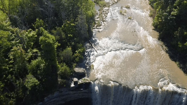
And now we arrive on top (in Niagara), at the Lockport Formation, which begins with the Gasport. The Gasport Member is blue-grey limestone-dolostone with crinoids and thick beds. If you’re lucky you may find some rough corals in the Gasport which can reach 10 meters thickness. Above the Gasport is the Goat Island Member, named after the island atop Niagara Falls. The Goat Island is light brown dolostone with thin beds and some development of chert. The Eramosa member is the top of the Lockport, it is a bituminous dolostone, meaning a dolostone with some shaley beds that have minor coal development. The Lockport formation in Niagara is the top, it is the resistant layer over which the Niagara Falls flow.
There are a few more units that are higher stratigraphically than the Lockport Formation around south-western Ontario, such as the Guelph Formation which brings us into the Upper Silurian (or Late Silurian chronologically). The Guelph is a tan-brown dolostone with thick beds and a significant gas deposit.