MOLA Topography
1 2016-06-01T08:35:03+00:00 Frank Fueten dee05431475b87c68ebf15bbea4bfeac11808e9e 11 1 Using MOLA data through October of 2000, the Science Team has produced a very high resolution topographic shaded relief map of Mars. The map has a resolution 0.125° (300 dots per inch) and is shown as a mercator projection to latitude 70° north and south. For a larger map, click on the image at left. plain 2016-06-01T08:35:03+00:00 Frank Fueten dee05431475b87c68ebf15bbea4bfeac11808e9eThis page is referenced by:
-
1
media/Mars_partial_map.jpg
2016-06-01T10:54:23+00:00
Mars Tectonics
63
image_header
2022-02-07T18:12:25+00:00
In this section we'll discuss tectonics on Mars. We just examined the topography so you most likely have already concluded that Mars has not developed a system of Earth-like plate tectonics. And you would be correct. Mars has a very old surface which is dominated by craters. You might then expect that we would find the same contraction features that we saw on Mercury and indeed Mars has wrinkle ridges which we will discuss a bit later. But Mars also experienced significant volcanic activity, examined in more detail later, and very often volcanic activity and tectonics are linked. And so we'll start with the largest volcanic feature on Mars, the Tharsis bulge, which is also responsible for the most significant tectonic feature on Mars. Details of the volcanism are discussed later, for our purposes here, the important aspect is that a large, ~10 km high pile of volcanic rock erupted onto the crust. This happened early in Mars' history, likely ~3.7 billion years ago.
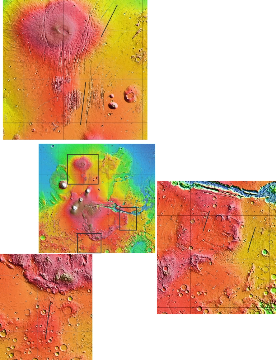
Please recall that the crust is simply the outer, rigid shell of the planet. It floats on top of a layer that is able to flow more easily. If a large weight is placed on the crust, it depresses the crust. [Note: if you wish to learn more about this check out isostasy. A local example is isostatic rebound, in which Ontario's crust is still rising, after having been depressed by glacial ice during the last ice age. The main point we want to make here is that the mass of the Tharis bulge depressed the Martian crust. Because the crust is a rigid, rocky shell, it does not bend easily; it fractures and deforms. Because of that applied load, we find many tectonic features radiate out from Tharsis or are concentric to Tharsis. The image on top of this page is part of the geological map of Mars. All those black lines with ticks on them are faults. The image below illustrates this by selectively zooming into three areas around Tharsis, shown in the three black squares.
Many of the radiating features are grabens, sections where the crust has been pulled apart or undergone extension. If you scroll to the second page of this abstract, figure 3 has a nice 3D diagram of how the crust has deformed. The area of this study is just to the right of our top black box on the image above.
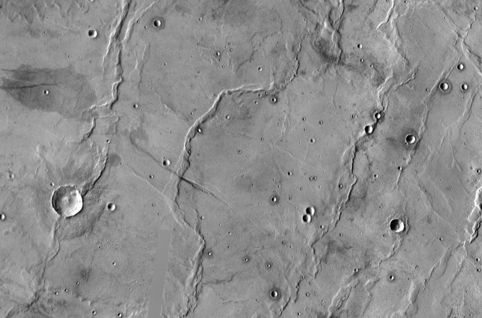
But most of the features are related to contraction such as these wrinkle ridges in the image below:
So far we have discussed tectonic features caused by the Tharsis load, let us now turn to the big feature within Tharsis, Valles Marineris.Valles Marineris
As stated in the topographic overview, Valles Marineris is a 400 km and up to 11 km in depth set of largely interconnected chasms. It is often referred to as a rift, but if our best understanding of how it was produced is correct, then it is very different from terrestrial rifts. Let us take a closer look, this is what the whole system looks like in Themis imagery:
Valles Marineris is not a single simple chasm, but a whole system of chasms that are largely connected and are elongated in the same direction. The chasms are bounded by faults and it is clearly a very large tectonic feature. But most estimates of how far the sides of the chasms have separated have indicated that extension has only been on the order of a few 10s of kilometers, even though the narrow chasms, such as Coprates Chasma are well over 100 km in width. So Valles Marineris was not created like terrestrial rifts by producing new ocean floor and moving the continents aside. So, what's the answer?
Valles Marineris is located in the Tharis bulge, so it must post-date it. The Tharsis bulge appears to cover the dichotomy, that change between high crust to the south and lower, thinner crust to the north. Indeed geophysical data indicates that the dichotomy continues below the Tharsis bulge (note: this means the dichotomy-causing impact predates the formation of the Tharsis bulge). The load that Tharsis put on the crust (discussed above) affected the thinner lower crust more than the thicker southern crust. As a result of this differential load, tension along that boundary caused a large fracture system to form. Movement along the sides of that fracture zone was primarily by vertical collapse. This collapse was aided by infilling of the troughs with sediment as the collapse began. In this model, the mass of the sediment keeps pushing the collapsing bit further downward. [We will visit these sediments, which are now large mounds, in the water module as they are an important part of the history of water on Mars]. Much of that sediment has now been eroded and removed. After the collapse, the sides expanded outward primarily by erosion and landslides. We find evidence of many landslides along the walls of Valles Marineris. Please note that this is the condensed, big picture version of the story. What we've described in a few sentences took place over possibly 100 million years with undoubtedly more complexity. For example there is good evidence that some of the isolated basins formed first and were later connected and there are still issues that need resolving. But we do know that Valles Marineris is very different from a rift on Earth.A note about other rifts on Mars
You will already have noticed that the abstract we included above used the word "rift" and if you search the scientific literature on Mars you would notice that it is widely used and that there have been many studies of such rifts. But what do these authors conclude? We use this study as an example because it asks the question directly.
In the full publication the authors do an excellent job of documenting the features of the Thaumesia Graben (TG) and then comparing those feature to terrestrial rifts. Let's quote their conclusion in full:On the one hand, the TG displays some features that are common to terrestrial continental rifts: The overall dimension, the fault pattern of its master fault systems, and the local change of polarity of half graben. On the other hand, the TG lacks several essential characteristics of terrestrial continental rifts: A regional domal uplift, the formation of a through-going rift valley, a flank uplift, and rift-related volcanism. From a morphological and structural point of view, therefore, the TG can hardly be seen as a useful analog to terrestrial continental rifts.
Marsquake!
NASA's InSight mission landed the first ever seismometer, called the Seismic Experiment for Interior Structure (SEIS) instrument on Mars on November 26, 2018. Seismometers record ground motion, including by earthquakes (or rather, marsquakes on Mars), which occur when tectonic pressures built up inside a planet are released suddenly by breaking of rock along faults. Other types of ground movement that might be recorded by seismometers might also include volcanic eruptions, meteorite impacts, wind, or in the case of InSight, robotic movement of the spacecraft. The first marsquake detected by SEIS was recorded on April 6, 2019. This is the first recorded trembling that appears to have come from inside the planet, as opposed to being caused by forces above the surface, such as wind. Scientists still are examining the data to determine the exact cause of the signal.Summary
As we have seen Mars has not developed a system of plate tectonics, but it has many tectonic features on its surface. Early in its history, the cratered crust would have been thinner and more readily deformed by convection currents on the mantle. This would have produced features that share some similarities with features on Earth. Later that history would also have included the contraction of the planet and the development of wrinkle ridges. But the single largest feature, responsible for the development of tectonic features was the emplacement of the Tharsis bulge on top of the dichotomy. Its mass caused many deformation features within the crust and it is ultimately responsible for the formation of Valles Marineris, the largest system of chasms within the solar system.
P.S. The geological Map of Mars is pretty spectacular and essentially fresh off the presses (2014). You can download it and the accompanying documentation freely from the USGS site here. If you're still looking for the perfect gift for your Favorite Martian, you can even order a hardcopy.
-
1
media/Mars_topo.jpg
2016-06-01T08:20:51+00:00
Mars - Topography Overview
36
image_header
2022-02-04T21:32:05+00:00
So far in this module we visited tiny worlds (Mercury and Moon) that were dominated by cratering and volcanism and found that even our sister planet Venus (at least size-wise) has surface features that are very different than those on Earth. We will now examine Mars, which is only approximately half the size of our Earth. Even though it is small, it is for us humans the most desirable planet in the solar system after Earth. If we want to settle on it, we should have a clear idea of its processes and conditions. That is why in this as well as in subsequent modules we will examine it in considerable detail.
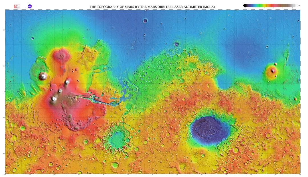
Let's start by examining the the global topography of Mars. This topography was taken by a now-defunct laser altimeter and is referred to as MOLA topgraphy (A variety of versions, can be found here). The elevations in this diagram range from less than - 8 km (dark blues) to higher than 12 km (white). On Earth the "datum", or the elevation assigned a value of 0, is defined by the elevation of sea level. On Mars sea level cannot be used because there are currently no oceans on the planet so a datum of zero elevation has been defined in relation to a constant atmospheric pressure.
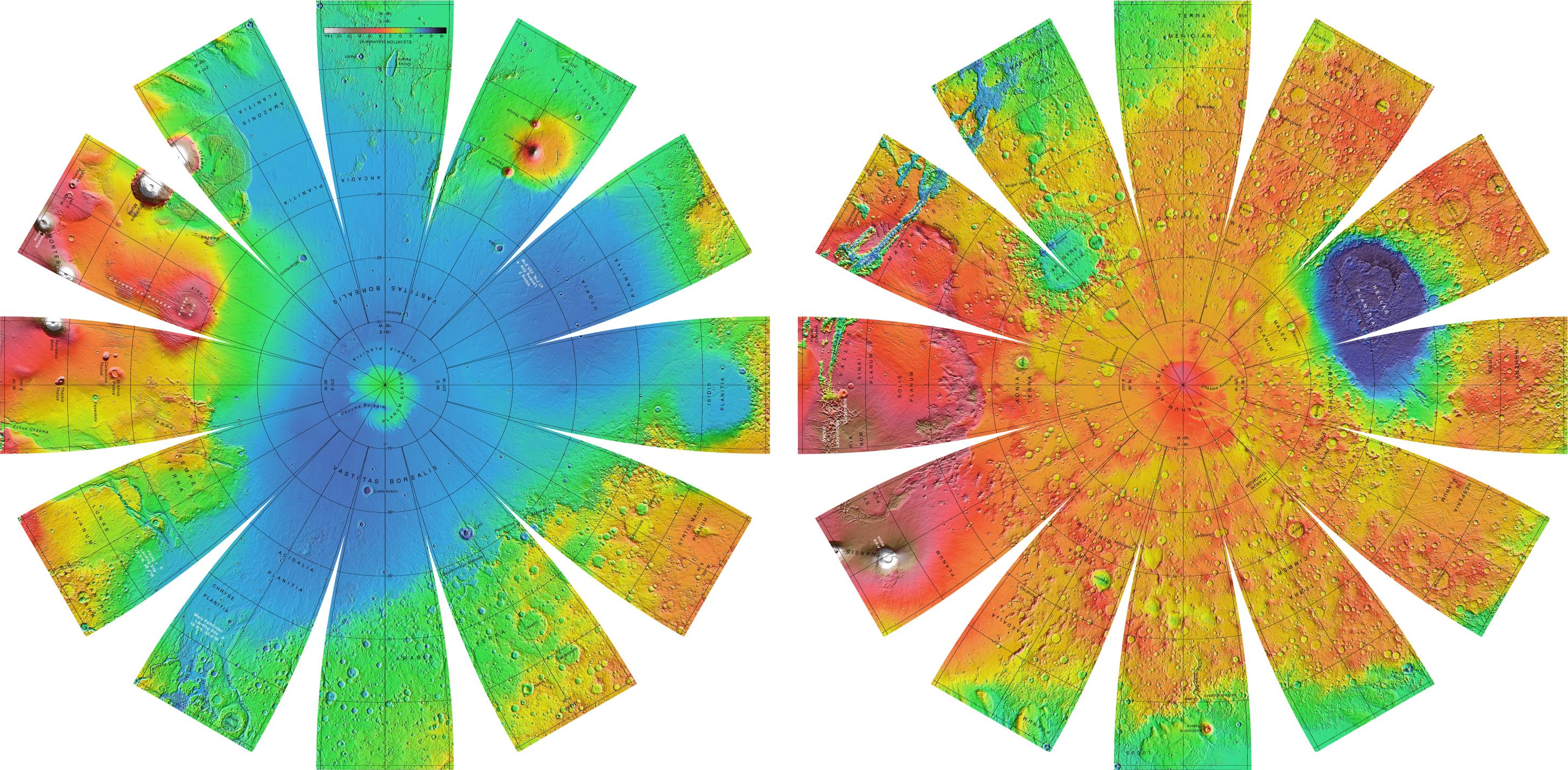
A few things stand out immediately. The majority of the southern portion of the planet is higher (reds) than the northern portion (blues). There appear to be more craters in the south, including some very large ones. For example, that very large blue basin is called Hellas Planitia (often simply referred to as Hellas basin). It is a 2300 km wide impact crater, which makes it one of the largest impact craters in the solar system (Ottawa to Saskatoon is about that distance) . By contrast the northern hemisphere (blue) has fewer large craters and is predominantly at a lower elevation. It has actually been suggested this North Polar Basin is the result of an early, very large impact. The outline of the blue region actually fits an ellipse with dimensions of approximately 10,600 km x 8,500 km as you can see in the slightly unusual projection here.
The ellipse would have been produced by an oblique impact and later volcanism would have modified the outlines somewhat. If confirmed, this would be the largest impact crater within the solar system. Clearly, cratering has been an important process in shaping the surface. But there is so much more!
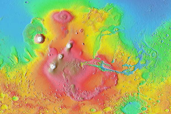
The boundary between the southern and northern hemispheres is referred to as the Martian Dichotomy. It marks the change in elevation which varies between 1 km - 3 km and is fairly abrupt in some areas while in other regions the transition is more gradual. The shades of green of the dichotomy are disrupted by a large region of high elevations (red). This is the Tharsis region, which may also be referred to as the Tharis bulge (its high!). Here is a closer view of it:
The Tharsis region is a ~10 km high (hence bulge) plateau that is thought to be largely of volcanic origin. We will say more about it when we address Martian volcanism in more detail. For now let us introduce a few more of the spectacular features that can be found here. Those three aligned white peaks are three large volcanoes, the Tharsis Montes. The very tall white peak further to the west is Olympus Mons, the largest volcano in the solar system. And last, but certainly not least, that long valley in shades of blue on the eastern side of Tharsis is Valles Marineris, a 4000 km long and up to 11 km deep system of chasms.
This concludes our global tour of the Martian topography and the large scale features we find in it. Cratering is an important process on Mars but it obviously has more to offer. In the subsequent pages we will take a closer look at some of these other features.