Europa’s sub-surface ocean
Early Voyager 2 images of the surface of Europa clearly demonstrate that surface is young (few craters) and very active. The image at the top of this page is from the more recent Galileo mission, named after the astronomer Galileo Galilei. (Cue the Indigo Girls.) The surface can only be active if the layer below it, the mantle, is not a solid, rigid layer. Since the mantle of icy satellites is composed of, well ice, a mobile mantle capable of flow suggests that the mantle might be a watery liquid. Hence for the last nearly 40 years, scientists have hypothesized that Europa has a liquid, sub-surface ocean. A more close-up view of the surface with many different grooves that cross-cut each other illustrates a very active surface.
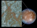
Here is a better close-up of the surface of Europa:
The caption for this image states:
Left: surface features indicative of tidal flexing: lineae, lenticulae and the Conamara Chaos region (close-up, right) where craggy, 250 m high peaks and smooth plates are jumbled together.
This six frame mosaic of Europa's surface shows a variety of interesting geologic features. The prominent "X" near the center of the mosaic is the junction of two "triplebands." Triplebands are seen here to be made up of parallel sets of ridges, and can be traced for over 1,600 kilometers (off the image) across Europa's surface. Directly to the south of the "X" is a 75 by 100 kilometer (km) area where the icy crust of Europa has been disrupted by activity from below. This activity could be motion in liquid water, convection in warm ice, or some other process. Many icy blocks, some as large as 10 km across, have been rafted from the edges of this zone. Also seen in this mosaic are various pits and domes that range in size from a few kilometers to nearly 20 km across. These geologic features provide evidence of thermal activity below Europa's surface at the time that the features formed. These images were obtained by the Solid State Imaging (CCD) system on NASA's Galileo spacecraft during its sixth orbit around Jupiter. North is to the top of the picture, with the sun illuminating the scene from the right. The center of this mosaic is located near 10 degrees north latitude, 271 degrees west longitude. The image, which is about 300 by 300 km across, was acquired at a resolution of 180 meters per picture element. The Jet Propulsion Laboratory, Pasadena, CA manages the Galileo mission for NASA's Office of Space Science, Washington, DC. JPL is an operating division of California Institute of Technology (Caltech). This image and other images and data received from Galileo are posted on the World Wide Web, on the Galileo mission home page at URL http://galileo.jpl.nasa.gov.
You will notice in that description the phrase "This activity could be motion in liquid water, convection in warm ice, or some other process". While the Galileo data provided clear evidence of motion below the icy shell, it could not eliminate the possibility of a warm convecting icy shell. There were no geysers that served as a
In 2007 researchers used magnetic measurements made by the Galileo probe and modeled the conductivity of the mantle of Europa. They estimated the thickness of an ocean within Europa using measurements of its magnetic field. The assumption was that the ocean is saline and therefore conductive. Their best estimates suggested that the thickness of the interior ocean of Europa is somewhere between 25 and 100 km. If we knew exactly how saline the water was, we could relate the magnetic measurement to water depth. Unfortunately at present we do not know this, and the authors of the paper suggest that 100 km or less seems to fit best with the most reasonable assumptions.
Things are actually a bit more complicated as is pointed out in this paper on the temperature of the ocean in Europa. We cannot simply assume that the temperature or the salinity of Europa’s ocean is the same throughout. If temperature and salinity vary, the ocean may be stratified (remember, the densest water is ~4C). This complicates any possible heat transfer from a warmer rocky core to the outer icy shell. The authors suggest that most of the interior ocean may actually be at the maximum density of water and that this volume convects heat. This volume is separated from the icy shell by a thin layer of water that is near the melting point and therefore less dense. For the purpose of our module and until we have a better understanding of the interior of these icy satellites, we should simply realize that there appear to be salty oceans underneath those icy shells but that we cannot simply assume that all of the water has the same composition or temperature. And to directly link the properties of water discussed at the beginning of this module with the discussion of subsurface oceans, we quote the last paragraph of the paper on the temperature Europa’s ocean. The author’s state:
Water is a peculiar substance. The possibility that a subsurface liquid water ocean might exist at all is due to the peculiar fact that solid water is less dense than liquid water. It may be that another peculiarity, the fact that water is most dense at a temperature higher than its melting point, is responsible for not only the tectonic style of Europa’s surface, but the overall age of the surface.
NASA is presently in the planning stages for an orbiter mission to Europa (launch date not yet set), so stay tuned for future discoveries. Also, we will revisit some of these icy worlds when we discuss the possibility life in the solar system.