Mars
The role of water on Mars in the distant past
When we talk about ancient Mars we consider a time period approximately 3-4 billion years ago. The late period of meteorite bombardment was just ending (~3.8 by). At present Mars' atmosphere is a mere 0.6% (~ 6.0 mbar) of the atmosphere of Earth, it would have been warmer and had more water. Please watch this video because it explains how we obtained the data and the implications of the findings rather nicely:As the video states, Mars has lost 86% of its early water. Nobody disagrees with that statement. But we should probably point out that there is a significant debate within the scientific community about whether that water was frozen for much of that time. This debate is sometimes phrased as "warm and wet" or "cold and icy". In a "cold and icy" scenario, the ice would only melt for geologically short periods of time, which principally greatly reduces the chances of life taking a foothold on Mars. For our purposes we will focus on the features associated with liquid water. But if you want to read more about the "cold and icy" Mars, the authors of this article have a nice discussion here.
So, what other evidence do we have for liquid water on ancient Mars? There has been a such long-standing discussion about Lakes on Mars that a 410 page book entitled "Lakes on Mars" was written which reviewed the evidence to date. There are principally two different types of terrain that could serve as lakes on early Mars. Most of the large lakes that have been proposed on Mars are within large craters. Many of these large craters date from the early history of bombardment and they would therefore have been present during the wet period. Within these lakes we find evidence of layered rocks that look like sedimentary rocks on Earth and we also find channels that appear to have served as passage ways for water to enter the crater. Evidence from orbiting satellites has been convincing for many of these craters. An even better understanding of the geology of such a setting has been provided by the current Curiosity mission. Curiosity is currently examining the interior of Gale Crater, a 154 km wide impact crater with a large interior mound, thought to be composed of sediments. Rather than examining a large number of craters, we'll focus on Gale crater and the evidence of a watery past that we find within it.
Gale Crater, the Curiosity rover landing site
You may have heard about the hair-raising Seven Minutes of Terror about the challenges of landing Curiosity on the Mars surface, or remember the global excitement when it did land. Since landing on August 6, 2012, the Mars Science Laboratory (MSL) rover, Curiosity has been operating in Gale Crater. The over-arching goal of the MSL mission is to identify and assess whether Mars ever had environments that were habitable for microbial life. In this subsection, you will see that MSL has been enormously successful in reaching this goal.Gale Crater is 154 km in diameter and notable for its large (5.5 km tall) “mound” of layered rock visible from orbit. The mound is informally called Mount Sharp, or Aeolis Mons, if you want to be more proper. From orbit, the CRISM instrument onboard the Mars Reconnaissance Orbter (MRO) detected spectral signatures of water-bearing clay (also called phyllosilicates), sulfate, and iron oxide (hematite) minerals in the lower layers of Mount Sharp. Based on what we know about the occurrences of these minerals on Earth, they must have formed in an environment that was wetter than Mars is today.
You can make out many surface features, including craters and the dark-toned sand dunes (called Bagnold dune field) surrounding the base of Mount Sharp in this stunning video of the rover’s decent to Bradbury Landing in Gale Crater. This video was captured by the MARDI (Mars Descent Imager) camera located on Curiosity’s underbelly.
While Mount Sharp is an amazing sequence of sedimentary rock, you really can’t land a rover on the side of a mountain! The rover had to trek almost 12 km (and taking almost 2 years) before it even reached the lowest layers of Mount Sharp. But as a bonus, the geology within the landing ellipse also provides ample evidence for a wetter ancient Mars. Located in the north rim of Gale Crater is an outflow channel called Peace Vallis that empties out into the landing ellipse. Water running down a steep canyon (like Peace Vallis) flows rapidly and is capable of transporting sediments downslope, including centimeter-sized pebbles. But when that water encounters a flatter surface, such as the lower plains surrounding Mount Sharp, it slows down and deposits the larger pebbles and coarse sands in a fan-shaped feature called an alluvial fan.
The abstract below gives more detailed information about the Peace Vallis fan.
Bradbury Landing (small cross in image above) is located near the end (terminus) of the Peace Vallis alluvial fan network. Curiosity has examined fluvial conglomerates, which are rocks composed of lots of rounded centimeter-sized pebbles. These rocks are thought to have deposited from fast-flowing water.
In addition, thinly layered rocks composed of very fine grains (so fine in fact that they cannot be resolved by microscopic imaging), called mudstones, have also been examined by Curiosity in an area known as Yellowknife Bay as well as in rock layers comprising the lower reaches of Mount Sharp. Fine-grained, layered rocks are known on Earth to deposit from calm waters, such as a lake environment. The lake in Gale Crater apparently dried out from time to time as evidenced by possible mudcracks in the rock.
Curiosity drilled into these mudstones and collected a sample of powdered rock in order to determine their mineral make up. Curiosity confirmed the existence of water-bearing clays (phyllosilicates) in these rocks, which points toward a potentially habitable lake environment. These exciting findings are well described in the video below:
The inferred extent of the Gale lake system is represented by this map. The lake was likely intermittent, meaning it periodically dried out and was fed by snowmelt outside the crater. Recent findings however suggest that the lake system may have been much larger than first thought and may have partially filled Gale Crater.
If you are interested in learning more about what one of your professors (Mariek Schmidt) does on the MSL mission, check out this Brock News story:
Valles Marineris
Another location which is thought to have been the location of large lakes is Valles Marineris, the 400 km long system of chasms that are up to 11 km deep. While most of the chasms are now connected, in the early stages it is through to have consisted of a series of isolated basins.
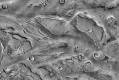
Many researchers think that the isolated basins were filled with water and were in fact large and deep lakes. One line of evidence for this theory is that a significant portion (~17%) of the floor of these basins are filled with very large layered deposits we believe to be sediments (often referred to as Interior Layered Deposits). We will only take a look at one of these deposits, referred to as Candor Mensa below. As shown in image (A) Candor Mensa is located at the approximate center of Valles Marineris, near the boundary between two chasms (West Candor, Ophir).
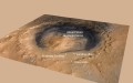
As far as we can tell, Candor Mensa is a single, very large sedimentary deposit, it measures approximately 115 km x 70 km and is nearly 8 km high. (Please recall that Mount Everest is 8,848 m high - some features on Mars are very large.) A satellite image of Candor Mensa is shown in image (B) and the topography in (C). While there is no vegetation on Mars, we still find that bedrock details are obscured by what are probably late ashfall deposits. But in the bright areas in (B) we can see exposed bedrock. And that is what is shown in image (D). In (D) you see a 3D image of a small area. Those dark lines running approximately up and down are dunes that are much younger than the underlying rock. The lines that go across the image are the layers, which range from 4 - 10 m in thickness. By studying the geometry and the chemistry of that layering, several researchers have come to the conclusion that the best explanation for this and similar deposits is that they formed in lakes. These lakes may have been frozen for much of the time.
Outflow Channels and Valley Networks
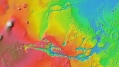
More evidence of flowing water comes from large outflow channels and valley networks, which look more like rivers. If you look back to the large image of Valles Marineris you will notice large channels leading from the high (red) areas to the low (blue) areas. Our example here is Kasei Valles. These are thought to be produced by large and probably periodic releases of large amounts of water. The most likely source for those large releases of water are the catastrophic release of possibly frozen groundwater. And that brings us to another source of water.
It's below the Ground
Groundwater, that is. Just as on Earth, Mars it thought to have had a considerable amount of groundwater in the past. There is an active discussion within the scientific literature as to the amount of water, the scale of ground water circulation, the chemistry of the water and how much of that water may have been trapped in subsurface ice. It may have had an important role in cementing sediments (loose material you can dig with a shovel) into sedimentary rocks (hammer required). So, please be aware that it existed, but we'll leave it there.
The role of water on Mars at present
Not only has Mars lost most of its water as we said earlier, the conditions on the surface are different than they were 3-4 billion years ago. It is colder and the atmosphere is thin. If you look back at our phase diagram for water, you will notice that the atmospheric pressure of ~ 6.0 mbar is very close to the triple point of water. In fact at the current atmospheric pressure, liquid water is not stable on Mars and can exist only for a short time. So we know that at present no lakes can exist on Mars. Water is stable in ice form, but if exposed to the open air, it would sublimate, or directly turn to vapour. We were able to visually confirm this in 2008, when the Phoenix lander dug a small trench near the northern polar region. In it there was some white stuff (ice) that disappeared after a few days. This was proof that we were looking at water ice because if it had been carbon dioxide ice, it would not have sublimated. (BTW, sublimation is also the answer to the mystery of why the ice cubes in your freezer shrink and may eventually vanish.)OK, so we know there is water ice in the polar caps and that there can't be any lakes. But the question of the possible existence of sub-surface ice or water remained. Probing the sub-surface of distant planets is not easy and we didn't begin to get clues to that question until new cameras achieved orbits around Mars in 2006. One of these cameras is called HiRISE and it is able to obtain images of the Martian surface with resolution of 30 cm/pixel. You can see these images here.
Well, after several years of observing Mars, researchers noticed that on the interior of some craters, thin, dark streaks appeared periodically. By taking repeated pictures over the same region it became clear that these streaks were primarily present near the equatorial regions and that they appeared on the sunny side, during spring and summer. Eventually they were referred to as Recurring Slope Lineae (RSL). This 2012 abstract gives a nice overview and illustrates that they are primarily located near the equator - if you look at their figure 2.
There has been a lot of follow-up work since 2012, because, well, the world didn't end, and we now have a number of spectacular examples. And this is what they look like in detail. In this animated gif you can see a sliding scale at the top which indicates when the images were taken. This particular example from Newton Crater (full explanation if you follow that link) is based on 6 images and you will notice that the RSL (the dark streaks) rapidly appear in the spring and summer.
More recently, data from an orbiting spectrometer (CRSIM on the same orbiter as HiRISE) which can measure the composition of the ground, determined that there were salts at the end of the RSL. And so, in the fall of 2015, researcher concluded that indeed a salty, briny solution of water was seeping out of those rocks and running down those slopes. And so, it took multiple years to arrive at this conclusion. To quote Rich Zurek, a project scientist with the mission that contains the instruments (referred to as Mars Reconnaissance Orbiter (MRO)):
There are still a number of unresolved issues. We still don't know how much subsurface water there is, and we don't know their source. They may not be springs like we have on Earth; an alternative suggestion is that there are deposits of salt that absorb water (like those little silica packs you find in shoe boxes) and then release that water when heated."The ability of MRO to observe for multiple Mars years with a payload able to see the fine detail of these features has enabled findings such as these: first identifying the puzzling seasonal streaks and now making a big step towards explaining what they are,"
Update November 22, 2017
Back to the RSL. In a new paper in Nature Geoscience, researcher are now suggesting that the evidence is more compatible with granular flows of fine particles and hence does not involve water. One of the lead author stated in this release that:
"We've thought of RSL as possible liquid water flows, but the slopes are more like what we expect for dry sand," said USGS scientist and lead author Colin Dundas. "This new understanding of RSL supports other evidence that shows that Mars today is very dry."
We'll leave it to the last paragraph of this nice discussion to summarize what that means:
So where does that leave us? The paper argues that we're right back where we started: we don't expect liquid water on the surface of Mars, and the RSL simply aren't conclusive evidence of it. "Flowing liquid water in the current Martian climate has always been an extraordinary claim," the authors write. "The observations and interpretations presented here suggest that RSL are no longer extraordinary evidence." As long as we're not sure what they are, they can't be used as evidence of anything else.
But the big picture questions have been solved. There used to be water on Mars, and there is still water on Mars. It just may not be dripping out the hills. But, there is no reason not to go there!
This page has paths:
This page references:
- Seven Minutes of Terror
- Curiosity descent MARDI video
- Estimated size of ancient lake associated with Peace Vallis in Gale Crater
- Palucis et al., 2013, Origin and Evolution of the Peace Vallis Fan System
- NASA | Measuring Mars' Ancient Ocean
- Lakes on Mars
- Valles Marineris Topography
- Candor and Baetis Mensa
- Kasei Valles, seen in MOLA elevation data.
- Kasei Valles
- Oblique view of Gale Crater
- Peace Vallis and alluvial fan near the Curiosity rover landing ellipse and site.
- Link rock outcrop on Mars compared with a terrestrial fluvial conglomerate – suggesting water vigorously flowed in a stream channel.
- Rover Report: Curiosity hits pay dirt