Plate Tectonics
Many of the large scale features of the Earth, such as mountain belts, ocean basins and volcanoes, are the result of Plate Tectonics which is a collection of processes that affect the entire planet.
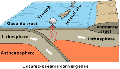
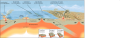
You will recall from the section on the differentiation of the planets that the interior of the Earth is divided up into different regions that differ in terms of their chemical composition, temperature and mechanical properties. The rigid crust makes up the surface of the Earth and it is firmly attached to the rigid upper portion of the mantle and together they make up what geologists call the lithosphere. Below the lithosphere is the asthenosphere, which is the upper part of the mantle that is relatively soft and deformable (it flows in response to an applied stress) and the crust and lithosphere "float" on that mobile portion of the mantle. There are two types of crust, "continental crust" and "oceanic crust" (see the diagram, below). Continental crust, as the name suggests, makes up the continents (extending under the oceans where seawater laps onto the continental margins), it is relatively thick (averaging 35 km in thickness) and it has a composition that is, on average, similar to that of granite. Oceanic crust lies beneath most of the worlds oceans and it is thinner (averaging 6 km in thickness) and it has a slightly greater density than continental crust because it has an average composition of the rock type called basalt which is rich in relatively heavy elements such as iron and magnesium.
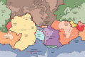
The crust and the lithosphere are broken up into a number of fragments that vary greatly in size; these fragments are called plates (specifically, "tectonic plates" or "lithospheric plates"). The next figure (below) is a map showing the Earth's major tectonic plates. All together there are a total of 19 plates that exceed 1 million square kilometres in area and more than 50 "microplates" that are less than 1 million square kilometres in area.
These plates move independently of each other and that movement involves forces that also cause the formation of large scale features of the Earth's crust. The term "tectonics" refers to the major structural features (e.g., mountains, ocean basins, continents, etc.) of the crust so that "plate tectonics" refers to the processes that involve the interaction of crustal plates to produce tectonic features.
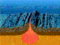
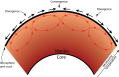
The plates move in response to convective motion within the mobile portion of the mantle (asthenosphere). You have seen that within the Earth the temperature increases from a maximum in the core to a minimum at the surface of the crust. Within the asthenosphere hot material rises from its depths and once at the top of the mantle it flows laterally beneath the crust and lithosphere as it cools. Cooling increases its density so that it eventually sinks back to the hotter, deeper regions where it heats up again and continues the convective process. Lithosphere and crust that is in direct contact with horizontally convecting mantle are dragged in the direction of convection. Where two convection cells are adjacent to each other convection is either upward where hot material is rising or downward where cool material is sinking into the mantle. These types of motion create very different boundaries between plates. The illustration below shows how mantle convection drags the crust to form areas of convergence and divergence within the crust. The red arrows in the mantle shows the motion of convection and the black arrows above the crust show the direction in which the convective motion will move the crust.
PLATE BOUNDARIES
There are three important types of boundary that may exist between tectonic plates:
- Divergent plate boundaries: plates move away from each other on either side of the boundary (e.g., oceanic ridges)
- Convergent plate boundaries: plates move towards each other on either side of the boundary (e.g., oceanic trenches and/or mountain belts)
- Transform boundaries: two plates slide horizontally past each other, in opposite directions on either side of the boundary (the boundary is called "transform fault"; a vertical fracture in the crust on either side of which movement is in opposite directions)
Divergent Plate Boundaries
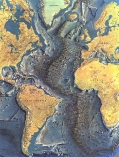
Most divergent plate boundaries are hidden beneath the oceans where new crusts forms as magma (molten rock) intrudes from the upper mantle into the overlying crust along a global fracture system that is expressed as the largest continuous feature on the planet, the oceanic ridge. The following map shows the world-wide distribution of the oceanic ridge; its longest continuous segment is 65,000 km long and its total length is about 80,000 km.
The ridge is a submarine mountain chain made up of volcanoes that reach the surface only locally (e.g., Iceland is a volcanic island that formed when volcanoes of the ridge grew to elevations that are above sea level). Over most of the world's oceans the ridge crest is well below sea level (on average 2.3 km below sea level) and lies, on average, about 3 km above the surrounding sea floor. The oceanic ridge is a massive tectonic feature that has a width of about 1000 km, giving it a total volume of about 80 million cubic kilometers.
Along much the length of the central axis of the oceanic ridge, there is a 1 km deep valley or trough. During the 20th century Cold War this trough had immense value for Soviet and American nuclear submarines because they could move long distances around the world without detection within the cover of the trough. "Hunt for Red October" is a great movie starring Sean Connery; "Red October" is a Typhoon class Soviet sub and much of the "hunt" takes place along the mid-Atlantic trough.
Along the ridge, magma with the composition of basalt is injected into the crust and erupts at the the surface, forming the volcanic mountains that characterize the ridge. The addition of new crustal rocks along the ridge system pushes older rocks further and further away from the ridge. This new basaltic crust is relatively thin and dense so it forms “oceanic crust” with its surface below sea level. This process leads to "sea floor spreading" because the sea floor becomes more and more expansive as new crust forms along the ridge axis. The animation below illustrates sea floor spreading along an oceanic ridge. Sea floor spreading rate is defined as the distance that a point on the crust moves away from the ridge axis over a given period of time (distance divided by time) and ranges from about 16 cm per year to under 1 cm per year and the average rate of spreading is approximately 2.5 cm per year.
When a ridge begins to form within a mass of thicker continental crust, it first forms a “rift valley” that becomes wider over time. As more crust is added, the rift valley eventually evolves into a new sea floor and, ultimately, if it continues long enough, a new ocean basin. The volcanically active East African Rift Valley is in the initial phases of this evolution and may well evolve into a new ocean basin separating western Africa from southeastern Africa.
Convergent plate boundaries
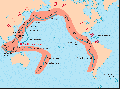
While new crust forms along the oceanic ridges, old crust must be destroyed or else the Earth would just keep on expanding. Along convergent margins old crust is lost in two different ways: by subduction and/or by compressive deformation. The map below shows the distribution of convergent and divergent plate boundaries and the direction of plate movement around the world.
If an oceanic plate converges on another oceanic plate, one slab will dive beneath the other and be "subducted" into the upper mantle. The subducting slab bends downward and passes beneath the over-riding slab and the line along which the two slabs intersect forms a linear topographic low called an "oceanic trench". The subducting crust heats up as it descends into the mantle and releases water into the overlying materials, which then melt and rise into the over-riding plate, penetrating it locally through vertical fractures and once at the surface produces volcanoes. These volcanoes commonly build to above sea level where they form linear chains of islands that lie parallel to the oceanic trench; such a chain of volcanoes is called a "island arc". The following figure illustrates this type of convergent plate boundary.
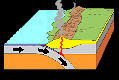
When a plate of oceanic crust converges on a plate of continental crust, the oceanic crust is always subducted (because it is made of basaltic rocks, which are denser than the granitic crust that makes up continents) forming an oceanic trench. Adjacent continental rocks are compressed by the forces generated by plate convergence and they buckle and break, resulting in a thickening of the continental margin, and forming mountain chains that run parallel to the adjacent trench. In addition, magma that is generated by melting of rocks above the subducting slab rises upwards and penetrates the continental margins to produce volcanoes at the surface, within the mountain chain. The following figure illustrates a convergence of oceanic crust on continental crust.
The map below shows that most convergent plate margins are found surrounding the Pacific Ocean basins (two exceptions are the Sandwich Islands in the south Atlantic Ocean and the region adjacent to Puerto Rico). The blue lines delineate well-defined trenches whereas the red-shaded areas are regions of plate convergence but without well-defined trenches on the sea floor. Note that the Aleutian and Japan trench represent convergence of oceanic crust on oceanic crust and the associated island arcs are prominent on the map. The western edges of North and South America are examples of oceanic crust converging on continental crust and the Rocky Mountains and the Andes Mountains, respectively, lie parallel to the convergent margin, having been constructed by the compressive forces and volcanic activity that characterizes this tectonic setting.
A third common type of convergent plate boundary exists when continental crust converges on continental crust. In this case, neither plate subducts because both are too buoyant to sink readily into the upper mantle. Instead of subduction, the plates push against each other and the rocks are folded and broken and pushed upwards to form mountain belts all along the region of subduction. The modern Himalaya Mountains are still forming in this manner after a plate that was made up of India collided with the southern edge of the Eurasian plate about 20 million years ago. The following animation shows the collision between converging continental plates. Note that it begins with ocean crust subducting beneath continental crust but then a continent that is attached to the subducting plate converges to form the mountains within the larger continental mass that results from the collision.
Transform Plate Boundaries
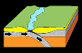
Transform plate boundaries develop between offset segments of oceanic ridge as shown in the figure below. Transform boundaries are also called "transform faults". In geology a "fault" is a fracture or system of fractures in the crust and on either side of the fractures the crust is moving in opposite directions. In the figure, below, rocks on either side of the transform fault move away from the associated oceanic ridge axis but due to the offset in the ridge the movement on either side of the fault is in opposite directions.
Along the oceanic ridge there are thousands of transform faults as shown in the following realistic illustration of the sea floor along the mid-Atlantic oceanic ridge. In this image the ridge trends more-or-less north south (up and down) whereas the transform faults trend approximately east-west, offsetting the ridge axis.
The tell-tale signs of Plate Tectonics
The following figure summarizes the various types of plate boundary and how plate tectonics operates. Note that it also identifies specific types of volcanoes that are associated with various plate boundaries. We will see more about volcanoes in the next section.
If we were to evaluate whether or not plate tectonics was operating on Earth on the basis of satellite photos alone, then we would look for the large scale structures that plate tectonics produces. If we were to find these structures on other planets, they may well mean that plate tectonics is (or was at some time in the past) operating there as well.
These large scale structures include linear mountain belts that are produced in association with continental-oceanic crust convergence and along zones of continental collision. Oceanic trenches and volcanic island arcs also indicate that plate tectonics has been at work. Oceanic ridges in otherwise flat basins are a particularly prominent outcome of plate tectonic processes but these are largely hidden on Earth by a couple of kilometers of seawater. On a dry planet, such ridges would appear as long chains of volcanic mountains with a central trough and transform faults that appear as valleys extending at right angles to the oceanic ridge.
This page has paths:
This page references:
- Oceanic crust converging on oceanic crust.
- Animation of sea floor spreading
- Animation showing convergence of oceanic crust on continental crust.
- Animation showing continental crust converging on continental crust.
- Oceanic and continental crust
- Typhoon class submarine like the fictitious "Red October".
- Summary of types of plate boundaries.
- Tectonic Plates
- world distribution of oceanic ridges
- Mantle convection beneath lithosphere and crust
- Major oceanic trenches and zones of plate convergence
- Transform boundary
- mid-Atlantic oceanic ridge
- Direction of movement of tectonic plates