Mars - Water and Ice
Flowing Water
The oldest evidence of flowing water on Mars is found in old valley networks that dissect the oldest crust on Mars, the southern highlands. This figure shows the distribution of the valley networks in red and they are clearly concentrates on the older and higher crust , south of the dichotomy. (Note that for many of the images in this section, you can click on it to zoom and and scan the image at high resolution.)In detail they resemble terrestrial river networks, with branching tributaries. The image below is Warrego Vallis, an area where the branching morphology is very high. This kind of drainage network suggest precipitation and surface runoff, similar to what we see on Earth.
But those valley network are quite rare in younger terrain. Instead, we find some of the most dramatic examples of flowing water, large floods, referred to as Megafloods. As the name implies, these are large scale floods, usually triggered by a sudden release of water. In this example of the megaflood, a large crater filling lake overflowed. The location is on top of the Tharsis plateau, near the eastern end of Valles Mariners, just south of Ganges Chasma. The 78 km wide Morella crater breached with a volume equivalent to the combined volumes of Lakes Erie and Ontario. The fact that the flood formed 2 large channels and clearly covered a very large area (see scale) indicates that the crater was breached and discharged quickly.
Another method that can lead to floods happen on Mars is that an impact causes melting of large volumes of subsurface ice, which then drains away. In this example, we examine channels in the ejecta of the 125 km wide Hale crater. The channels appear on the outer edge of the ejecta and the flow of water has been capable of cutting into the ejecta blanked and moving the material. This is a close-up view of one of these channels:
Liberating water through impact is thought to be an important mechanism in Martian history.
Outflow channels are large channels that covers significant area and drain a single large feature, such as Valles Marineris. The image at the top of the page is Ravis Vallis, which emerges from the rubble filled depression on the left. It is thought to have been formed by sudden release of groundwater. Another example of an outflow channel is Kasai Valles, which you see below. We'll visit it again in the water module, but we want to point out a few general aspects of outflow channels here. The flooded areas tend to contain crater and crater rims can be much more resistant to erosion than the surrounding country rock. As the result the flood water move around the crater and often the material behind the craters erodes less than the material in front of them. This results in tear drop shaped remnants. In the image below you can see how the craters affected the flow of water.
The other important point we need to make is the period of free flowing water was fairly short-lived. There are examples of channels that are younger, such as the 2 billion year old channels shown below. But the author of this example points out that the more recent activity was likely a series of relatively short events, on the order of <100 years. As mentioned above, the periodic source of water for individual flows may have been ice that has been melted by impacts.
Summary
As we have seen above, water did indeed shape the surface of the planet. But the way water shaped the surface of Mars changes over time. The earliest evidence suggests a much more active hydrological cycle, later activities are much more indicative of episodic events. And that is a trend that continues. When we revisit Mars in the Water module, we'll see that the trend of decreasing water activity has continued. But it is not just water that has shaped Mars, ice has also played a role.
Flowing Ice - glaciers
At present the largest visible deposit of ice is the northern polar ice cap, which consists largely of water. This is an image of the north polar ice cap as taken on March 3, 1999.The light-toned surfaces are residual water ice that remains through the summer season. The nearly circular band of dark material surrounding the cap consists mainly of sand dunes formed and shaped by wind. The north polar cap is roughly 1100 kilometers (680 miles) across. Image Credit: NASA/JPL/MSSS
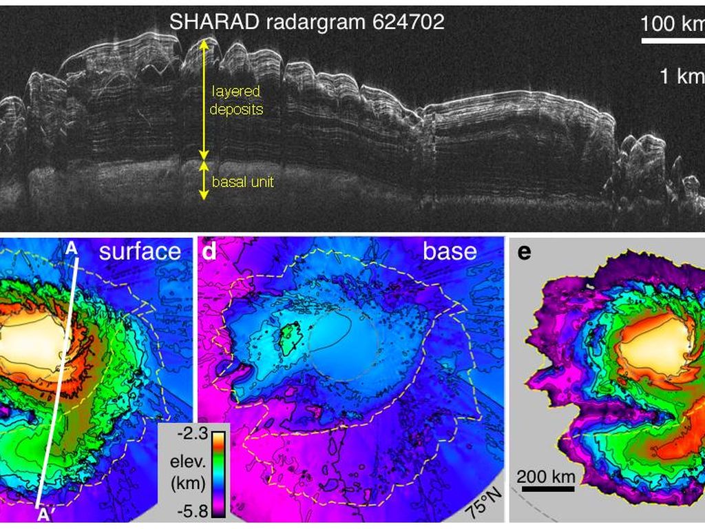
Using a space borne radar instrument, SHARAD, we can map the layers underneath the north Pole as can be seen in the image below. Please note that the vertical scale has been exaggerated by a factor of 100. Full explanation for it is here.
we have found evidence of glaciers that are currently buried under and protected by a thick layer of dust . As stated in this press release, they tend to be concentrated in a belt further away from the poles. As stated by researcher Nanna Bjørnholt Karlsson:
The glaciers are located in belts around Mars between the latitudes 300-500 – equivalent to just south of Denmark’s location on Earth. The glaiciers are found on both the northern and southern hemispheres.
These glaciers hold a lot of ice:
“We have calculated that the ice in the glaciers is equivalent to over 150 billion cubic meters of ice – that much ice could cover the entire surface of Mars with 1.1 meters of ice. The ice at the mid-latitudes is therefore an important part of Mars’ water reservoir,” explains Nanna Bjørnholt Karlsson.
But perhaps some of the most surprising findings are that we now believe that in the past glaciers were strong erosive forces, shaping the planet even in equatorial locations, such as Valles Marineris. And that requires a bit of an explanation, which we will keep as short as we can:
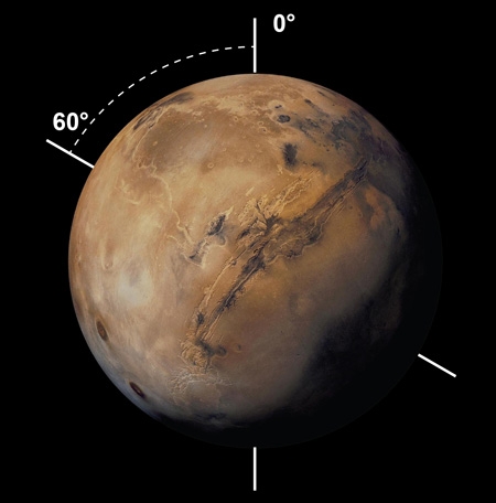
The Earth's orbital parameters such as the tilt of its rotation axes with respect to it's orbital plane (obliquity) is not constant, but varies slightly between 22.1 and 24.5 degrees. Nevertheless, this small variation affects our climate. Note, there is obviously much more to this and if you like a fuller explanation start with Milankovitch cycles. The important point is that variation on Earth is minor. Mars is subject to much larger variations in tilt axis, we believe up to 60° and as the result the climate variations are significant.
Climate models have demonstrated that during periods of high obliquity, areas such as Valles Marineris would become sites where ice accumulates. The main reason why Mars undergoes such large swings is that it lacks a large moon that helps to stabilize the orbit. In fact recent data indicates that Mars is just emerging from an ice age. Radar data of the north polar ice cap shows that ice has recently (~400,000 years) been accumulating more rapidly than prior to that time. The interpretation is that Mars is just emerging from one of those extreme tilts in rotation axis. Read all about it - here.
Back to Valles Marineris.
Climate modelling has shown that during those times of high obliquity Valles Marineris is a place where we expect snow and ice to accumulate. And there have now been a number of studies pointing to a large variety of features within Valles Marineris that we now attribute to glaciers but we will just show a couple of examples.
The authors of a 2014 paper entitled "One million cubic kilometers of fossil ice in Valles Marineris: Relicts of a 3.5 Gy old glacial landsystem along the Martian equator" have also put together a more publicly accessible post on the "Planetary Geomorphology Image of the Month" site. They consider the entire system of chasms to have been filled by glaciers as can be seen in this figure:
Those glaciers are responsible for many of the large scale erosional features we see inside the chasms. In addition the interaction between ice and and unstable chasms walls has produced some very unusual landslides that we find within several chasms. If you wish to read the entire post, which includes more images it is included below or as an external link here.
We will finish this section by showing you a smaller scale example of a Martian feature and it's terrestrial analog, which is located about a day's drive away from Brock in northern Ontario. The example comes from a paper on small sedimentary deposits within Coprates chasma. The top of the image depicts the scours within the Martian mound. The bottom images depict well know terrestrial features that formed during glacial times in northern Ontario.
Summary
As we have seen the surface of Mars has been shaped extensively by both running water and by the action of glaciers. However, most of that activity too place during the early stages of Mars' history, probably 3-3.5 billion years ago. As we will see in the module on water, the activity of water on present day Mars is much more limited.
Update January 11, 2018
According to the study cited in this press release some of the ice may still be readily accessibly in non-polar region.
The new study not only suggests that underground water ice lies under a thin covering over wide areas, it also identifies eight sites where ice is directly accessible, at latitudes with less hostile conditions than at Mars' polar ice caps. "Astronauts could essentially just go there with a bucket and a shovel and get all the water they need," Byrne said.
So, stay tuned...