Flowing Water
Module 4 is all about water in the Solar System, but in this section of Module 3 we will focus on Earth surface features that are produced by water. Of course ocean basins are the largest bodies of water and ocean basins on Earth are produced by plate tectonic processes (sea floor spreading). In this section we will focus on large scale features produced by water flowing over the Earth's surface (river channels and drainage patterns).
The Earth is unique in our solar system in that it has an abundance of flowing liquid water at the planet's surface. All together there is 1,386,000,000 cubic kilometres of water (fresh and saline) on the Earth's surface and in the atmosphere and, on average, 2,120 cubic kilometres of that water (or 0.0002% of the global total) is flowing in the rivers and streams at any given time around the world. Earth is the only planet in the Solar System that currently has active rivers because on all of the other planets the surface temperature are everywhere too cold to allow water to exist in its liquid state. However, as we will see later in this module, there is evidence of flowing water on the surface of Mars in the past and that evidence is the presence of large scale features that have all of the characteristics of river channels on Earth (ergo, flowing liquid, most likely water in this case, was present at the time that the Martian features formed).
River Channels
When water falls on the Earth's surface as rain, or as frozen snow and ice melts, it flows down the slope of the land surface in response to gravity. As it flows along the surface, it exerts viscous forces on substrate over which it flows and if those forces are sufficiently strong they will erode material from the surface and any solid particles that are produced will move downstream, in transport by the flowing water. The rate at which water flows through a channel or channel system is referred to as the river's discharge: the volume of water that passes through the river at a given location over a specified period of time. Units of discharge are commonly in cubic metres per second. Over time, with sufficient volumes of water flowing over the surface, this erosion will lead to the formation of channels that are cut into the substrate. It's important to note that within a channel at any given instant there are areas where erosion is taking place and other areas where the fluid forces are weak and material that was in transport is temporarily deposited. Therefore, river channels include areas of local erosion and deposition that, together, determine the overall form of the channel.
The two most common types of channel are braided channels and meandering channels.
Braided Channels
Braided channels tend to form on relatively steep slopes and the sediment that is transported by the flowing water is relatively coarse (sand to gravel size material). The banks of braided rivers are made up largely of sand and gravel that is relatively easy to erode and so the channels are very dynamic in that they move laterally over time as the flow erodes the banks, altering the details of the channel system fairly rapidly over time. Another characteristic of braided rivers is that the discharge varies considerably over the calendar year, in many cases becoming dry or almost so during the periods of the year with little rain, but when a significant amount of rain falls or snow melts the channels quickly fill with rapidly flowing water.
Braided channels are characterized by multiple, interconnecting channels that pass around sand and gravel bars that extend above the water level. The photo below shows a braided river in New Zealand that was taken when flow in the channels was low. The river in the photo is experiencing low flow discharge (much less water is present than during periods of high discharge) and displays the diagnostic channels and bars very well. The river channel system occupies its entire floodplain (the area that is covered by water during high discharge, flood events; in the photo the floodplain extends from vegetated bank to bank across the photo) and when the discharge through the river is large (high flow) the entire floodplain will fill with flowing water to form one broad channel and the details of the braided pattern are obscured. Under flood conditions, the submerged sand and gravel bars migrate along the channel and then remain more or less dormant until the next flood event takes place.
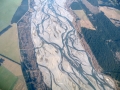
Braided channels are relatively common on alluvial fans which are produced where a single channel flows from a confining valley on to an open plain. Sediment in transported through the valley and once at the plain it is deposited to form a fan-shaped body over which the channel will advance as more and more sediment is delivered to the plain. Because of the relatively steep slopes the channels are most commonly braided. The figure below shows a classic alluvial fan with a single braided channel system extending over its surface.
Meandering Rivers
Meandering rivers develop on lower slopes than braided rivers, the sediment that is in transport is commonly dominated by very fine silt and clay that moves in suspension within the flowing water. The banks of meandering river channels are dominated by cohesive muds that resist erosion and make it more difficult for the channels to migrate laterally on the floodplain. In fact, while braided river channel systems extend across their floodplains meandering rivers have a single channel at low discharge. Meandering rivers experience much less variation in discharge over the course of the year than braided rivers.
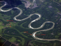
A meandering river is characterized by a single, sinusoidal channel that extends along the length of the river's floodplain. The channel itself makes up a very small portion of the floodplain which becomes fully submerged during the highest discharge events (like the spring floods that occur during snow melt in climates like that experienced in most of Canada). The figure below shows a single meandering river channel along with the vague impression of old, abandoned channels that have become filled over time (all we see on the surface is a vague outline of the channel that is called a "meander scar). While meandering channels are less laterally mobile than braided channels they do migrate slowly across and down the floodplain due to a pattern of erosion and deposition that is related to the form of the channel. Specifically, on the inside of each meander bend there is net deposition of sediment that leads to the formation of what is called a "point bar"; a body of material that is is commonly dominated by sand size sediment. On the outside of the meander bed erosion takes place for form the steep "cut bank" that is indicated in the photo below.
At a meander bend the channel migrates across the floodplain as sand is deposited on the point bar and sediment of the adjacent floodplain is eroded at the cut bank. Under the right conditions erosion of the cut bank can lead to the abandonment of parts of the channel and the meander scars in the photo were abandoned in that manner. The abandoned segment of channel becomes a part of the floodplain and with repeated flooding of the floodplain the old channel becomes buried under sediment that is laid down during floods. The signature of a meandering river is the single sinusoidal channel.
The following figure provides a visual comparison of meandering (left) and braided (right) channels on Earth.
Drainage Patterns
Drainage patterns are the large scale arrangement of the channel systems that are cut by a river. The drainage pattern that develops depends on the overall morphology of the land surface, particularly its slope, and underlying geology.
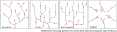
Refer to the figure, below, in the following description of common drainage patterns on Earth. Note that in the figure the black lines represent the path of the channels and the red arrow heads indicate the direction in which the water is flowing.
On simple surfaces that slope in one direction and are underlain by material of uniform geology the typical drainage pattern that forms is a "dendritic" pattern where the channel segments merge with other channels in the downstream direction so that there are fewer channels as you move downstream; eventually all of the water flows into a single large channel near its downstream limit. The dendritic pattern resembles the branches of a tree with the large down stream channel making up the trunk.
The "trellis" drainage pattern is characterized by long parallel segments of channels that extend along valleys that are separated by uplands from which water drains. Short segments of channels, at right angles to the longer segments, join rivers from parallel valleys. This is a common drainage pattern in the Canadian Rocky Mountains.
When channel systems tend to follow fractures or faults that cut through underlying bedrock a "rectangular" drainage pattern develops if the fractures or faults define an approximately rectangular pattern.
Rivers flowing off a large dome shaped structure, such a a large volcano, produce a drainage channel pattern that radiates outward from the highest point forming a "radial" drainage pattern.
When observed on other planets, these patterns strongly suggest that running water played a role in shaping their surfaces too.
This page has paths:
This page references:
- Comparison of satellite views of meandering (left) and braided (right) river channels.
- Alluvial fan with braided channels: a 60 km long fan with braided channels dominating its surface. Flow is from upper left to lower right.
- Waimakariri River, New Zealand: a braided river channel
- Meandering river channel
- Four common drainage patterns on Earth.